Sorted by date Results 26 - 50 of 143

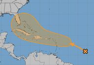
After a lull of several weeks without even a tropical depression, let alone a named storm, the Atlantic Hurricane Season is heating up again. August and September form the heart of the storm season, which peaks around September 10, according to historical records. Forecasters and computer models have alerted to the possible formation of a new cyclone this week in the vicinity of the Antilles. If the storm forms there, it is likely to track in the general direction of the...

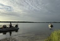
A 40-year-old Lake Wales man is dead after a kayaking trip on a local lake. A death investigation is underway following the recovery of the body of an adult male from Lake Annie, a 407-acre lake in the Waverly area of Lake Wales early this morning. Shane Park of Magnolia Street in Lake Wales had set out on the lake about 3:30 p.m. Sunday in a kayak. Weather at the time was fine, but thunderstorms began moving into the area a short time later. When he failed to return to shore...

A happy city staff, as well as grant consultants Lee Hale and Hilary Waers of Hale innovation, were celebrating before, during, and after the city commission workshop Wednesday. In a room decorated with balloons, City Manager James Slaton made the happy announcement that the city had received a grant award of $22.93 million from the US Department of Transportation. The RAISE grant for "Complete Streets" will assure the completion of the Lake Wales Connected plan, a...

After a serious months-long drought that saw falling lake levels and withered lawns and shrubs, southeast Polk and the entire region are finally expecting to see the start of the normal summer monsoon rains. Forecasts are calling for as much as 2" to 3" of rain in some locations on a daily basis this week, with areas that see repeated rounds expected to incur localized flooding. A saturated atmosphere and light steering winds will lead to the development of thunderstorms...

A team of civic-minded volunteers from Lake Wales Heritage took advantage of the rainier weather this week to work on the organization's ongoing streetscaping project. Monday morning found a team of volunteers planting nine young lemon bottlebrush trees on South 4th Street. The trees were replacements for some lost due to heat stress and drought this spring. "Now that the seasonal monsoon rain season has begun, the time is right," said Heritage volunteer director Preston...

Frostproof native Mason Gravley was part of a two-person team that has apparently established a new endurance record for Florida. The duo paddle-boarded approximately 34 miles over the course of 11 hours and 27 minutes, navigating the vast and unpredictable waters of Lake Okeechobee. Mason Gravley of Palmetto and Jordon Wolfram of Lakeland successfully completed the crossing on January 1 after a 5:00 am start, marking the first-ever recorded journey of its kind. The...

The drought and intense heatwave that has gripped the Ridge and most of central Florida has led Polk County to declare an outdoor burn ban which will go into effect next week. The move comes just as the 2024 hurricane season begins. The annual six-month cyclone season is predicted to be far more active than normal by the National Oceanic and Atmospheric Administration (NOAA) and a host of private weather predictions. NOAA's Climate Prediction Center has released a forecast...

Former Bok Tower Gardens carillonneur William N. De Turk Jr. passed away on Thursday, March 14 after a fall at his home in Lake Wales. The 78-year-old worked for the National Historic Landmark for 18 years, including seven years as director of Carillon Services. Only the third carillonneur since the opening dedication in 1929, De Turk succeeded Milford Myhre before resigning on Oct. 31, 2011. Myhre was the Singing Tower's second carillonneur who played the bells for 36 years...

With an election only three days away, three of five candidates seeking to occupy seats on the Lake Wales City Commission skipped a last chance to meet and hear from voters. Both incumbents skipped the chance to interact with voters, just as they had a March 4 forum hosted at the Lake Wales Woman's Club theatre. At an outdoor forum hosted in perfect weather at the B Street Center in the city's Northwest Neighborhood, only Carol Gillespie, seeking Seat 4. and Brandon Alvarado,...

Downtown Lake Wales was a "happening scene" Friday as the sounds of the south Florida-based "The JamBand" filled the air as they performed from a special stage in Linear Park. The event drew a large crowd on a beautiful spring evening who danced, clapped along, and sometimes sang with the band. Numerous vendors and a food truck catered to the crowd. The free performance was another installation of "Lake Wales Live," a six-performance series intended to help bring more...

Ideal weather conditions and a wide area of beautiful works of art are expected to draw residents and visitors alike to the shores of Lake Wailes this weekend as the 53rd annual Lake Wales Arts Festival take place in Lake Wailes Park. The show will be open from 10 a.m. until 5 p.m. on Saturday, and from 10: a.m. until 4 p.m. on Sunday. Seventy artists have been accepted into the juried showing hosted by the Lake Wales Arts Council and will offer an array of media and...

If you're planning to be out and about this week, you may want to "hold on to your hat" as another round of windy weather will follow bands of rain expected to begin on Sunday and continue into Monday evening. According to forecasters from the National Weather Service, an "anomalous" or unusually-strong low pressure system will move over Florida from the Gulf of Mexico during that period, creating the possibility of more strong thunderstorms. Widespread rain and showers are...

After weeks of rainy weather, accompanied by wild swings in temperature, a more stable near-term outlook is becoming established for Florida and most of the southern United States. A series of Pacific high-pressure systems are expected to replace the parade of arctic air masses that put much of the nation, and central Florida, under below-normal temperatures in recent days. Although we escaped freezing temperatures on the Ridge, residents are ready for a warm-up, and that's wh...

The wild swings of weather seen in central Florida in recent days is expected to continue this week with a dash of severe threats thrown into the mixture, as the long-predicted El Nino weather pattern takes hold here. The immediate concern is for Tuesday evening, when a strong, fast moving squall line is expected to pass over the Lake Wales Ridge with the potential for damaging winds. Cloud to ground lightning and a slight risk of tornadoes has been forecast as well....

Even as the Lake Wales area enjoys pleasant and mild weather, it's important to keep a weather-eye out for late-developing tropical storms and hurricanes that could threaten to disrupt our idyllic autumn days. Now two long-range models are depicting just such a potential. Hurricane season runs through November 30, and there have been occasional storms that have developed even after that date. The unusually-warm water in the Atlantic basin, coupled with unseasonable warmth,...

Major improvements are underway at the Lake Wales History Museum that are expected to make the facility a center of community activity as well as a draw for residents and visitors alike, according to Executive Director Melissa Stoller. The ongoing project includes needed repairs to the 98-year-old building as well as reimagined and refreshed exhibits. The non-profit museum is seeking volunteers with carpentry skills to help with the ongoing reconfiguration. Stoller promises...

It's time to start digging out the jackets and sweaters. The long-awaited seasonal cooldown after the end of an exceptionally hot summer will arrive in earnest next week after the passage of a series of reinforcing cold fronts. Heavy rains are expected over Florida beginning Wednesday night, and rain will linger for several days before a series of fronts sweeps in a colder air mass that will leave morning lows in the 50's for the Lake Wales Ridge area. The potential for...

An early-autumn bout of very soggy weather has left the Lake Wales Ridge area with as much as nine inches of rain in some locations, raising lake levels and saturating marshes. Now long-range models are beginning to depict a weather pattern favorable to tropical storm development in the western Caribbean. The wet weather has generally been welcomed across central Florida after a drier-than-normal year, and the various models are in agreement that the pattern will remain in...

After a two-day spell of autumn-like weather to mark the official start of the season this weekend, summer-like rains are expected to return to Florida, but the threat of a tropical storm or hurricane remains distant. Computer models are showing a benign pattern remaining over the central Atlantic basin, with protective upper-level winds deflecting storms northward and away from Florida. After the rapid pop-up of Tropical Storm Ophelia just off the east coast of Florida last...

As the 2023 hurricane season peaks this week, storm threats to Florida appear to be at low ebb. Conditions in the tropical Atlantic basin are continuing to deflect storms northward. As once powerful Hurricane Lee makes landfall on the coasts of Maine and Nove Scotia, Floridians breathed a sigh of relief. At is peak the storm reached the much-feared Category Five intensity, but Florida received nothing more than dangerously high surf and beach erosion. This week the first of a...

The strongest hurricane to form over the Atlantic basin in recent years may be in the offing as National Hurricane Center forecasters are predicting that now Tropical Storm Lee will strengthen into a fearsome Category Five hurricane by the weekend, menacing the east coast of the United States with winds of 150 mph or more after a period of "explosive" intensification. That rapid rise in power is largely due to heated oceanic temperatures, as much as three degrees above...

While multiple named storms have swirled harmlessly all week in the mid-Atlantic, a weak tropical wave that emerged off the coast of Africa several days ago is now the system to watch for Florida. The National Hurricane Center in Miami is now assigning the system a near-100 percent chance of development during the coming three days, during which time it is forecast to be approaching the area of the Virgin Islands. By that time it should be a powerful hurricane. Despite still...

After causing a scare in the east Polk region by approaching Florida from the southwest, Hurricane Idalia behaved much as the computer models had predicted, staying well offshore of Florida's west coast before slamming into the Big Bend Area of the state as a Category Four hurricane. That course left the Lake Wales area and surrounding communities undamaged due to winds. Three times during the overnight hours tornado warnings caused alarms to sound on phones and tablets in...

The rapid intensification of Tropical Storm Idalia into a major hurricane just off the west coast of Florida has Lake Wales area residents on edge. Three times in the last 19 years similar forecast tracks led to storms that turned east ahead of forecast, causing direct strikes on the city. Now forecast to become a hurricane today (Monday) before entering the Gulf of Mexico, Idalia is expected to reach Major storm status with a high likelihood of rapid intensification due to...

The possibility of a tropical storm or hurricane impacting Florida and potentially threatening the Lake Wales area is increasing as models are indicating the potential development of a new system in the western Caribbean. If the system strengthens, it would likely move near the western tip of Cuba before entering the Gulf of Mexico and approaching the west coast of Florida. The waters of both the Caribbean and Gulf of Mexico are far warmer than historic records, potentially...